Locara · Bangalore
Koramangala
People praise
- Connectivity rated 4.5/5 by residents (99acres)
- Rated 'much safer for those who stay with family or alone'
- Education + healthcare together score 4.0/5
- Vibrant mix of residential, commercial, and recreation seamlessly connected
People complain about
- Traffic jams at peak hours and difficult parking
- Road deterioration during monsoon
- Flooding after rain because of poor drainage
- High cost of living, especially rent and dining
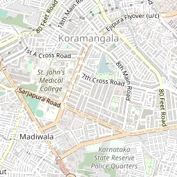
How safe is Koramangala?
85/100Regularly listed among Bangalore's lower-crime, more heavily policed areas across several safety rankings. This is its reputation; there is no official crime rate for the area.
Known as a low-crime, well-lit, heavily policed area with many professionals and expats. Usual night-time care still applies. This is safe by Bangalore standards, not a guarantee.
- Crime severity
- Low
- Street lighting
- Good
- Police station
- 0.8 km
- Fire station
- 2.5 km
Method
| Component | Reading | Points | Weight |
|---|---|---|---|
| women_safety_score | 72 | 72 | 0.4 |
| crime_severity | low | 100 | 0.25 |
| street_lighting | good | 100 | 0.15 |
| closest_police_station_km | 0.8 | 80 | 0.1 |
Weighted sum of the components above. A missing reading is excluded and its weight redistributed, never guessed.
5 sources
- sobha.com/blog/safest-areas-in-bangalore-to-live/
- kots.world/blog/the-safest-areas-in-bangalore-to-live-in-2025
- justdial.com/Bangalore/Policeh-Station-Next-Bethany-School-Koramangala-6th-Block
- justdial.com/Bangalore/Fire-Pump-Station-Koramangala/080PXX80-XX80-240926052725-
- data.opencity.in/dataset/bengaluru-and-karnataka-fire-stations
How do you get around?
69/100- Nearest metro
- Central Silk Board (Yellow Line)1.8 km · 23 min walk
- Buses
- Plenty of BMTC buses on the main roads (routes include 201-G, 342-F, 343, 360-K and KBS-3C/3F) to Majestic, Shivajinagar and Jayanagar. The inner residential streets have far fewer, so the walk to a bus stop depends a lot on your address.nearest stop 0.1 km
- Cabs and autos
- Excellent
- Traffic
- HeavySarjapur Road, 80 Feet Road and the Sony World and Sarjapur junctions are notorious; startup-office density keeps it busy through the day.
- Railway station
- Baiyappanahalli6.9 km
- Airport
- 40 km
- City centre
- 7 km
Peak-hour commute, one way
- Whitefield (ITPL)60 min
- Outer Ring Road (Marathahalli/Bellandur)35 min
- Electronic City45 min
- CBD (MG Road)25 min
- Manyata Tech Park (Hebbal)60 min
Indicative peak-hour drive times; they vary by route and day.
Method
| Component | Reading | Points | Weight |
|---|---|---|---|
| walkability_score | 58 | 58 | 0.2 |
| closest_metro_km | 1.8 | 65 | 0.2 |
| uber_ola_availability | excellent | 100 | 0.1 |
| bus_density | moderate | 60 | 0.1 |
| closest_bus_stop_km | 0.1 | 100 | 0.15 |
| city_centre_km | 7 | 60 | 0.15 |
| airport_km | 40 | 40 | 0.1 |
Weighted sum of the components above. A missing reading is excluded and its weight redistributed, never guessed.
What is daily life like?
100/100- Food delivery
- Zomato, Swiggyabout 30 min
- Quick groceries
- Blinkit works hereabout 15 min
- Eating out
- 331 restaurants and cafes mapped within 1.5 kmmeal for two around ₹2,000
- Groceries
- Well-served: Nilgiris has several branches (3rd Block BDA Complex, 16th Main, 5th Block), with Nature's Basket, Namdhari's Fresh and Reliance Fresh also in the area.19 supermarkets mapped within 1.5 km
- Domestic help
- Abundant
- Local market
- Madiwala Marketdaily, 1.4 km away, OpenStreetMap
- Shops close by
- Most retail and restaurants stay open past 11 PM on the main commercial stretches (80 Feet Road, 5th/6th Block).
- ATMs and banks
- 109 ATMs and banks mapped within 1.5 km
- Nightlife
- VibrantA busy pub and brewery cluster in 4th and 5th Block (Prost Brew Pub, Boho, Fenny's and Gilly's). Younger and cheaper than Indiranagar.
Method
| Component | Reading | Points | Weight |
|---|---|---|---|
| eateries_within_1_5km | 331 | 100 | 0.35 |
| supermarkets_within_1_5km | 19 | 100 | 0.3 |
| atms_banks_within_1_5km | 109 | 100 | 0.2 |
| domestic_help_availability | abundant | 100 | 0.15 |
Weighted sum of the components above. A missing reading is excluded and its weight redistributed, never guessed.
6 sources
- justdial.com/Bangalore/Nilgiris-Supermarkets-in-Koramangala-6Th-Block/nct-119682
- dontworrygotravel.com/top-restaurants-in-koramangala-a-foodies-guide-to-dining-o
- quickcommercemap.com/reports/bangalore-quick-commerce-2026
- thrillophilia.com/pubs-and-lounges-you-shouldn-t-miss-when-in-bangalore
- openstreetmap.org/copyright
- OpenStreetMap: restaurants, cafes, supermarkets, ATMs and banks mapped within 1.5 km of the area centre (2026)
Air, noise and the monsoon
64/100Koramangala sits on the Koramangala-Challaghatta drainage valley, a known flood-prone stretch of south Bangalore, where roads flood with water and waste in heavy rain. Residents on 99acres also complain about flooding after rain.
Main commercial roads (80 Feet Road, 5th/6th Block, Sony World Signal area) carry heavy traffic and nightlife noise; interior residential blocks are quieter.
- Air quality
- No reading specific to this area; Bengaluru's air is broadly moderate for most of the year, with haze in winter.
- Green spaces
- Moderate
- Lakes and water
- Agara Lake and Mesthripalya Lake are both within/near Koramangala and used for walking/recreation.
- Industry nearby
- None
- Stray animals
- Moderate
- Warmer or cooler
- ModerateRelative to other Bengaluru areas (the city's climate is otherwise uniform): green cover moderate, industrial proximity none. Per IISc urban-heat-island research, vegetation cover is the dominant driver of local land-surface temperature.
- Earthquake zone
- Seismic Zone II
Method
| Component | Reading | Points | Weight |
|---|---|---|---|
| noise_score (100=quietest) | 40 | 40 | 0.2 |
| flood_risk_score (100=lowest risk) | 45 | 45 | 0.2 |
| industrial_proximity | none | 100 | 0.15 |
| green_spaces | moderate | 60 | 0.1 |
| stray_animal_density | moderate | 60 | 0.1 |
| aqi_value | 64 | 80 | 0.25 |
Weighted sum of the components above. A missing reading is excluded and its weight redistributed, never guessed.
How are water, power and internet?
72/100On BWSSB supply. Some lanes have had low-pressure problems: from June, Teachers' Colony (1st and 2nd Avenue) residents reported low pressure, and a BWSSB test found no water reaching some lanes on 1st Main, 2nd Main and several other Avenues. The area also sits on the Koramangala-Challaghatta sewage valley, which affects drainage, not drinking water.
- Water source
- Mostly Cauvery (piped)
- Power cuts
- No recent power cut reports found.
- Roads
- 60/100
- 5G
- Availablegood on Jio, Airtel
- Garbage collection
- No regular complaints reported.
- Piped gas
- On GAIL Gas networkconnection depends on the building
- Parking
- ScarceCommercial and startup density with limited off-street space; on-street parking fills up through the day.
Method
| Component | Reading | Points | Weight |
|---|---|---|---|
| road_quality_score | 60 | 60 | 0.25 |
| network_5g | available | 100 | 0.15 |
| garbage_collection_quality | moderate | 60 | 0.2 |
| broadband_quality | moderate | 60 | 0.15 |
| gas_pipeline | true | 100 | 0.1 |
Weighted sum of the components above. A missing reading is excluded and its weight redistributed, never guessed.
Offices, schools and hospitals
97/100- Nearest tech park
- Enzyme Tech Park1.1 km
- Nearest mall
- Nexus Mall (Koramangala)1 km
- Nearest hospital
- St. John's Medical College Hospital0.9 km
- Hospitals
- St. John's Medical College Hospital is about 0.9 km away.
- Schools
- Schools here include National Public School, Koramangala (opened in 2003, on 80 Feet Road next to National Games Village).nearest 0.3 km
- School boards
- CBSE, ICSE, IGCSE, IB
- Colleges
- St. John's Medical College (about a 10-minute walk) and Christ University (about 3 km).
- Gyms
- Many
- Sports
- Lots of fitness studios. The BBMP park in 4th Block has a jogging track and outdoor gym. No large sports complex nearby.
- Parks
- BBMP Park (4th Block) is the named neighbourhood park with a jogging track; Agara Lake and Mesthripalya Lake add water-adjacent green space nearby.
- Coworking
- Many
- Places of worship
- 18+ Hindu temples and multiple churches (Baptist and Catholic).
- Pet care
- At least 5 vet clinics in the area.
- National Public School, Koramangala
- Babymona EHPS Koramangala
- Chinmaya Vidyalaya, Koramangala
- PNS School
- Bethany High School
- BBMP Park (4th Block)
- Agara Lake
- Mesthripalya Lake
- Akhila Park
- Leena Park
- Aurum Fitness
- Cult.fit 80ft Road
- Pumpit Fitness Studio
- Posh Fitness
- Reset
- Vetic Pet Clinic
- Crown Vet Koramangala
- V Care Pet Poly Clinic
- Pet Zone Pet Clinic
- Government Veterinary Hospital
Method
| Component | Reading | Points | Weight |
|---|---|---|---|
| closest_hospital_km | 0.9 | 100 | 0.15 |
| closest_school_km + school_names_nearby.length | 0.3km, 5 named | 100 | 0.12 |
| closest_mall_km | 1 | 100 | 0.1 |
| closest_tech_park_km + tech_parks_nearby.length | 1.1km, 5 named | 90 | 0.18 |
| gyms_and_sports_facilities_nearby.length | 5 | 100 | 0.12 |
| parks_nearby.length | 5 | 100 | 0.1 |
| coworking_spaces_nearby.length | 3 | 80 | 0.08 |
| places_of_worship_nearby.length | 5 | 100 | 0.1 |
| veterinary_clinics_nearby.length | 5 | 100 | 0.05 |
Weighted sum of the components above. A missing reading is excluded and its weight redistributed, never guessed.
8 sources
- en.wikipedia.org/wiki/Nexus_Mall_(Koramangala)
- en.wikipedia.org/wiki/National_Public_School,_Koramangala
- lbb.in/bangalore/jogging-at-koramangala-4th-block-bbmp-park/
- vetic.in/clinics/bengaluru/koramangala
- crown.vet/clinic-koramangala-vet-clinic.html
- kots.world/blog/top-tech-parks-in-bangalore-where-startups-and-mncs-grow
- ezyschooling.com/admissions/icse-school-admission-in-koramangala-bangalore
- openstreetmap.org/copyright
Who lives here?
High-energy and young, driven by startups and nightlife, and packed with cafes, pubs and co-living. One of Bangalore's most cosmopolitan areas.
- Mostly
- Young professionals, startup/tech workers, and a large student/first-jobber population given proximity to multiple tech offices and colleges.
- Households
- Skews toward singles and young couples/roommates in shared flats; fewer long-settled multi-generational families than older localities like Jayanagar.
- Income bracket
- Upper-middle
- Expat presence
- Moderate
- Pet-friendly societies
- Moderate
- You will mostly hear
- Kannada and English widely used; Hindi and other languages common given the large migrant professional population.
Culture and festivals
18+ Hindu temples and multiple churches (including Baptist and Catholic) in and around Koramangala.
What does Koramangala cost?
54/100- 1BHK rent
- ₹18,000approximate
- 2BHK rent
- ₹44,000approximate
- Buying
- ₹14,000 to ₹22,900 per sqft
- Bengaluru, 1 year
- +9%Knight Frank research, H1 2025 to H1 2026
- 5-year price change
- ~+31%99acres listings, approximate, last 5 years
- Bengaluru, 5 years
- +87%ANAROCK research, Q1 2021 to Q2 2026
- Rental yield
- 2.9%estimated from this area's 2BHK rent and price per sq ft (1,000 sq ft flat)
- The neighbourhood is
- Stable
- Coming up
- The Red Line metro (Hebbal to Sarjapur, Phase 3A) is planned to run through Koramangala. The state approved it in December 2024 but central approval is still pending, so it is years away (2030 at the earliest). Nearer term, the Blue Line's HSR Layout and Agara stations on the Outer Ring Road are due around December 2026.
Method
| Component | Reading | Points | Weight |
|---|---|---|---|
| rental_yield_pct | 2.9 | 50 | 0.3 |
| neighbourhood_stability | stable | 55 | 0.7 |
Weighted sum of the components above. A missing reading is excluded and its weight redistributed, never guessed.
What residents say
- Overall
- Positive
- In short
- Residents rate it about 4.2 to 4.3 out of 5 on 99acres. Well liked for connections, safety and its mix of homes, offices and nightlife, with traffic, parking, flooding after rain and high costs as the main complaints.
Praised for
- Connectivity rated 4.5/5 by residents (99acres)
- Rated 'much safer for those who stay with family or alone'
- Education + healthcare together score 4.0/5
- Vibrant mix of residential, commercial, and recreation seamlessly connected
Complained about
- Traffic jams at peak hours and difficult parking
- Road deterioration during monsoon
- Flooding after rain because of poor drainage
- High cost of living, especially rent and dining
Through the year
- Monsoon
- Koramangala sits on the Koramangala-Challaghatta drainage valley, a known flood-prone stretch: roads flood with water and waste in heavy rain, more than in most of the city.
- Winter air
- December to January is Bengaluru's worst season for air, as cooler nights trap traffic dust and fumes near the ground. Nearest government air monitor: Silk Board.